Archives for posts with tag: self-exploration

Today was our day to say adieu to good friends of many animal variety types but not goodbye! It was time to hit the back roads again headed south. I chose to take Hwy. 49 by Yosemite and Sequoia National Parks thinking I could go into one of them without spending my whole day.

However, the thoughts of crowds, bumper-to-bumper driving, noise, confusion and getting to Fresno after dark pushed me and my TomTom right past them. I’ll do them another time when I’m not in a hurry…not that I’m in a hurry on the back roads…I’m more in the mode to drive without all those things I mentioned above!

Hwy. 49 was a lovely scenery, curvy, mountainous road taking us in and out of these quaint little towns one could miss with the blink of an eye.

From prairie-lands

2016-5-29CA1

to  prairie-lands with mountains

2016-5-29CA2

To lush pastures full of livestock

2016-5-29CA3

To no pastures at all

2016-5-29CA4

To caves of trees covering the road!

2016-5-29CA5

And flowering bushes close enough to touch!

2016-5-29CA6

Then this!

2016-5-29CA7

And back again!

2016-5-29CA8

2016-5-29CA9

And into Angel Camp with clothes hanging across the road. What’s up with that?

2016-5-29CA10

2016-5-29CA11

OH! It must be in celebration of the upcoming fair and Jumping Frog Jubilee!

2016-5-29CA12

2016-5-29CA13

I’ve seen way too many lakes with horribly low water levels. Look for the old water marks on the banks of this one. Way too many in Nevada, New Mexico, Wyoming, Montana and now California tell the story. The other thing I’ve noticed this time on these back roads are a great deal of strip mining. Way too much of it is going on…way more than you think!

2016-5-29CA14

Tom and I had a disagreement about my taking this road…J59 (I think) but I’m sure glad I took it! This looked like silk blowing in the wind…for about 120 miles…in 97 degree heat!

2016-5-29CA15

And this just before I got on the 99.

2016-5-29CA16

Turns out that Fresno isn’t a safe place to be and that I got lucky when I picked the hotel where I’m staying tonight. The person at the front desk said that most of the hotels in Fresno don’t ask for ID or get your car tag number. Seems like every motel/hotel I’ve stayed in required that info. Glad I’m only here for one night!

I’m headed to LA for another respite and reunion! The good news is that I’ll be staying on the beach and I’m hoping don’t have to deal with the pollution too much. UGH!

HAPPY TAILS!

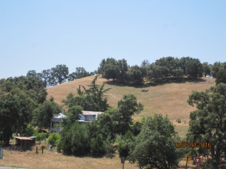
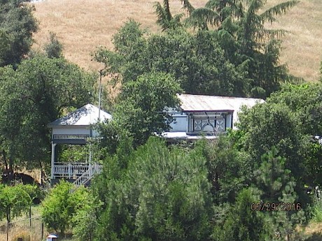
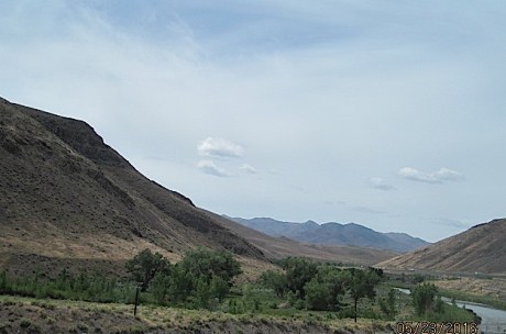
We’ve had the distinct pleasure and challenge (we being me and Montana) to stay in the home of a dear friend and true animal whisperer. This New York City born and raised woman never had any pets or room for them. However, as an adult, she’s made up for lost time!

Montana and I have shared this unique environment of cats, dogs, horses, ducks and rabbits for about a week now and they all get along amazingly well. It’s the guests who are challenged! Montana loves kitties and is in a constant cat-atonic state! Her nose twitches just like a bunny’s nose trying to figure out all the smells bombarding all her senses.

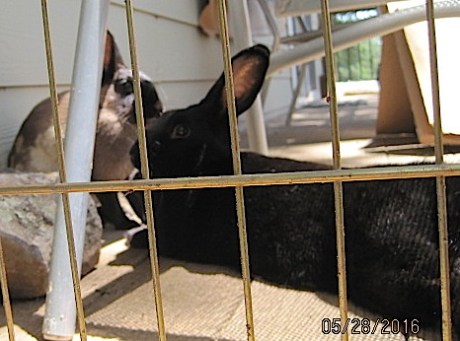
As my BFF neighbor will affirm, Montana truly loves her bunny play time. The ones here are quite a bit bigger than the wild ones in my front yard but that doesn’t keep Montana from lusting after them.

This is the best I could do with getting a bunny picture! I’m surprised they let me even get this close because Montana was at my side! I have to keep Montana on a leash all the time because of the openness of the environment. As I carried my salad to my seat with one hand and Montana’s leash in the other, she bolted through the doggie door toward not only the rabbits but a cat! She’d obviously been paying attention to the dogs running in and out of the doggie door after the bunnies have been put to bed and saw her moment. UGH!

2016-5-28CA1

A couple of years ago, my friend rescued a duckling. Of course she made it a pet and of course she got it a friend (as she did with all her foundlings). The male duck was supposed to be female but, as is true with many small animals, it’s not until they get older do you actually know exactly what you’ve gotten your hands on. So now there’s three!

The ducks are named Schnoooldz (mom), Dooodlz (dad) and Nooodlz (baby). Montana hasn’t really paid any attention to the ducks until today when Dooodlz flew off the handrail and did a nose dive into the mud. I had a close tether on her not knowing what she was going to do…or him either for that matter. Because he goes around hissing and flapping his wings all the time making sure everyone knows he’s the BOSS, my friend  aptly nicknamed him “rattlesnake!”

2016-5-28CA3

Nooodlz is about two weeks old.

2016-5-28CA4

My friend  has several names for each of her babies. She calls Schnooodlz  her “eagle” because she actually can fly. My friend has taught her to give “kisses” and to perch on her shoulder like an eagle! Who knew?

2016-5-28CA5

Dooodlz…the rattlesnake.

2016-5-28CA6

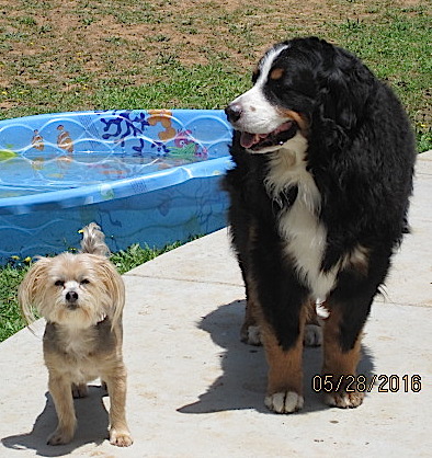
For dogs, she has them in three sizes: LARGE, Medium Large and small. Reno, a Bernese Mountain Dog, is “my” dog and weighs in at about 120 and is who I call Big Baby….because he is. He reminds me of my Newfie/Lab (Doobie) who passed in 2010.

The little scruffy dude next to him is Reign a/k/a The Enforcer.

2016-5-28CA7

This is Brody a/k/a Three Legs. He always looks confused! LOL No other name needed as I can remember numbers!

2016-5-28CA8

Then there’s the goat killer from the Caribbean she rescued while in medical school, Bella. Bella is the only dog to ever attacked the unsuspecting Montana so we were overly cautious when I first got here. Bella found a way out and charged Montana within seconds. Bella wanted to establish her pecking order to this new female!

Needless to say, I asserted MY pecking order and have continued my pack leader role by carrying around an empty water bottle that makes a very loud crackling sound when squeezed. If Bella even looks funny or if Montana even thinks about a cat or bunny I pull my water bottle from my holster and crackle away!

Bella’s a/k/a is Dingo Dog.

2016-5-28CA9

This is the only cat I could catch a photo of. I’m so confused about all the official and unofficial names of her menagerie that I’ve come up with my own. This one reminds me of Ava’s black cat Vinnie. She’s very curious about us and opens the bathroom door in the middle of the night when you think you’re alone.

My friend also rescued a large white fat cat from the Caribbean whose a/k/a is Cab Cat, one I call “Patches” and one I only catch a glimpse of so I have no feel for it’s other name.

2016-5-28CA10

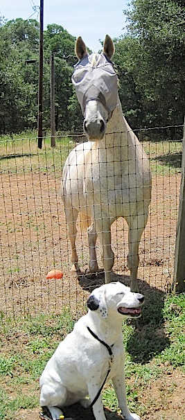
The horses are Jessie (red on the right) and Moose. Moose is “my” horse because when I met him years ago, I told her she needed to get him because he was so sad. He’s not any more! He’s no longer confined to a tiny area without any contact. He’s a retired professional barrel racing horse and I found that out a few years back when I goosed him to go faster not knowing he’d run full bore toward the gate! WHOA!

Montana hasn’t been too interested in the horses until Moose got a little too close to me and she stood up and touched his nose establishing his boundary with me.

2016-5-28CA11

This is Montana laughing at how easy it was for her to get that big dawg to back off! LOL

2016-5-28CA12

My friend is not only a great animal whisperer but an awesome friend. She’s been there for me and Ava many times over the years and I’ve loved having this time with her in her new digs.

Tonight we’re going to eat steak. A big ole juicy one at Ruth’s Chris’s Steak House! I’ll let you know how that works out for me being able to get an early start in the morning!

HAPPY TAILS!


When I was in Auburn the other day (when I was not taking pictures), I noticed a Thai restaurant and decided then and there that I was going back to see if their coconut milk  soup was as good as the one at my favorite Thai restaurant in Las Vegas or Dunwoody (a northeastern burb of Atlanta). It’s called Royal Thai in downtown Auburn (as opposed to the historic area).

I ordered off the lunch combo menu and was not disappointed! The coconut soup (a separate item) and the Massaman Curry dish with chicken…both items my all time favorites…were better than both my other favorite places! I highly recommend going to check them out the next time you’re in this area.

2016-5-27CA2

Then it was time to walk off some of that wonderful food so I drove to the historic area. It’s interesting when you realize that California didn’t become a state until after gold was discovered and that Congress “fast-tracked” it to becoming a state (learned that yesterday).

In perspective of the history of our country, I think of the 1600’s as old…not a pre-Civil War period! My ancestors came over about a hundred years before that which, from a European perspective, is still considered current history! However, it doesn’t take away the cuteness of this area’s western flair and mixture of people from every where.

2016-5-27CA1

This is a HUGE concrete sculpture of the person who discovered gold in this area. When driving up/down St. Hwy 49 and you see him, turn toward him and you’ll be in the historic district.

2016-5-27CA3

This has to be one of the oldest buildings in town called the Joss House. But, if you read the  Auburn plaque, you’ll see the number of times this town burned to the ground! That any buildings survived is pretty remarkable.

2016-5-27CA4

2016-5-27CA5

The good news is that it wasn’t as busy as Grass Valley was so finding a parking place wasn’t too difficult.

2016-5-27CA6

The weather here is surprisingly dry considering all the abundance of green vegetation and trees. It looks and feels a bit like where I live in the North Georgia mountains but without the humidity…and I’m not sure I’d like living in a green desert for very long! Use lots of lotion and drink plenty of water.

Tomorrow, I’m off to the back roads again headed south and then southwest.

HAPPY TAILS!


Pretty much most Nevadans agree that if it weren’t for mining and gambling, Nevada would be an empty state…well that and legal prostitution! Yesterday, I stopped in the middle of nowhere Nevada to get gas and catch the I-80 and was promptly met by a local to tell me that there were two houses of ill repute behind the station. It was a truck stop (duh) and had only one hotel….hmmm. I was tired but decided that one hotel wasn’t for me! LOL I pushed my way on toward Winnemucca.

Who knew that Winnemucca had a great little place for breakfast? It’s called “The Griddle.” It’s a cute 1950’s diner feel with great food. Other than that, there’s just gambling! To be honest, they say there’s some mining done there too but I never could find out what they mined there!

Over the last seven years when I was traveling, I’d traveled most of Nevada but somehow  missed the northwest corner…until today. I’m so glad I had a chance to experience the wonderment of it from prairie lands, to salt flats, to sand flats, to painted rock, and, finally, to an oasis. Enjoy it with me!

2016-5-23NV-CA1

You, literally, can drive a hundred miles without seeing more than a handful of vehicles or an exit. However, I found two exits within my first hundred miles this morning that only had a single dilapidated building at the end of that ramp! One such exit was Jesup, NV.

How did I happen to notice these? I took off from Winnemucca without filling up with gas and there wasn’t so much of an “authorized vehicle” median turn out to go back or anything until I saw a glimmer in the distance which looked like it might be a truck stop of some sort. As I got off the I-80, there was a faded fifty year old wooden sign notifying the weary traveler, “Welcome to Puckerbrush!” As I was solely focused on getting gas and getting on up the road, I didn’t go back for that money shot! I’ll have to get a photo of it next time I’m up there!

This is that exit for Jesup. Look at the cloud patterns in the sky! Looks like airplane patterns but there were no airplanes…or trucks or cars, for that matter!

2016-5-23NV-CA2


Then there were sand flats on the left side of the highway…

2016-5-23NV-CA7


Followed by salt flats on the left side…

2016-5-23NV-CA8

Then both…

2016-5-23NV-CA9

2016-5-23NV-CA10

And, all the while, prairie lands on the right side of the road.

2016-5-23NV-CA11

2016-5-23NV-CA12

As the left side of the highway evolves into prairie, salt, sand and water!

2016-5-23NV-CA13

Ultimately becoming an oasis!

2016-5-23NV-CA14

And painted rocks on the right side…

2016-5-23NV-CA15

With prairie lands on the left!

2016-5-23NV-CA16

Until, it’s only prairie on both sides of the highway with mountains in the distance.

2016-5-23NV-CA17

2016-5-23NV-CA18

2016-5-23NV-CA19

And an oasis with running water on the left.

2016-5-23NV-CA20

2016-5-23NV-CA21

2016-5-23NV-CA22

2016-5-23NV-CA23

The contrasts between states has never been more stark in comparison as it was between Nevada and  California when crossing the state line from Reno! BAM! Now it’s all GREEN! And SNOW!

2016-5-23CA1

2016-5-23CA2

2016-5-23CA3

I didn’t see this much snow at 7000 feet in Glacier National Park! Heck, I didn’t see any snow at Glacier much more than a light dusting on the trees for about 50 feet!

2016-5-23CA4

2016-5-23CA5

2016-5-23CA6

Although I prefer the back roads for my travel joy, I gotta say I-80 wasn’t bad at all. I’d so traverse this route again but West to East next time!

I’ll be in the same place for the next few days so I won’t have much to post but keep tuned in as I’ll be headed to LA next!

HAPPY TAILS!


I’m not sure if this blog is about the differences or the commonalities of Idaho and Nevada. Maybe it’s really both.

Southern Idaho is mostly agricultural, flat, lush green, has plenty of water, is easy on the eye with its rolling terrain, brilliant blue skies, lots of free range livestock ranging from cows, horses, sheep and goats. None of which northern Nevada can claim.

However, Southern Idaho interstates stretch for a hundred miles without even one pitstop, gas station or respite. Which, northern Nevada can be proud of out doing Idaho!

2016-5-22ID-NV1

2016-5-22ID-NV2

2016-5-22ID-NV3

2016-5-22ID-NV4

2016-5-22ID-NV5

2016-5-22ID-NV6

2016-5-22ID-NV7

2016-5-22ID-NV8

2016-5-22ID-NV9

2016-5-22ID-NV10

Northern Nevada, on the other hand, is anything but agricultural and all the other things I’ve mentioned about southern Idaho above. It has amazing diversity in topographic anomalies; big skies (but not like Montana’s); interesting reflections of clouds on mountains (first photo…dark patches are shadows from the clouds on the sides of the mountain); isolated rain showers in the midst of bright, clear blue skies and happy puffy clouds; rapid, radical topographic changes; arid climate; outwardly rocky terrain;

2016-5-22ID-NV11

Rain on a sunny day! Check out the two photo sequence below in contrast with the photo above taken only a few miles and minutes before.


2016-5-22NV2


2016-5-22NV4

Nevada’s rapid, radical topographic changes from above to the one below is downright psycho. It’s like the weather…wait five minutes and it’ll change!

2016-5-22NV5

2016-5-22NV6

2016-5-22NV7


2016-5-22NV9

2016-5-22NV10

2016-5-22NV11


2016-5-22NV13


2016-5-22NV17

Tomorrow, I head across Nevada toward Reno and Auburn, California where Montana and I will take a much needed respite at a friend’s (sistah by another mother). I can only hope it’ll be a respite because she has a myriad of pets which all cause Montana hyperventilation! It’ll either help desensitize her to bunnies, birds, cats, horses, elephants, lions and tigers or not! I’ve got plenty of Xanax for her anxiety and Omeprazol for her stomach! Heck. Now that I think about it, I hope I have enough for me too! LOL

HAPPY TAILS!

As a postscript to the Tail of the Dragon Road from my first post, it turns out that experience prepared me for yesterday’s harrowing drive on Hwy. 49 trying to get to East Glacier! I was still scared out of my wits driving that horrible, poorly maintained road with drops in the pavement, broken pavement and some of the scariest curves combined with rain, snow, fog and fear…but I did it! Probably got more gray hair but I did it!

As for today, I didn’t know the focus was going to be clouds and light. I thought it was going to be back roads of Idaho toward Twin Falls from Missoula, MT. However, when I plugged in the back road route I wanted to take, TomTom said it would take me TWELVE hours to get there! Map in hand, I searched for an alternative to see what results I got that way. It turned out that the only viable route to get close to my original destination was to head back South on I-15 through Montana…the way I’d traveled a few days ago to get to Kalispell.

This experience of traversing the same road in the opposite direction was magnified today as I kept checking to make sure I was on the right road because it looked so different. It may have been my fascination with all the cloud formations.

As soon as I headed South on Hwy. 93 out of Kalispell, the first inkling of today’s focus came to light…so to speak. My sister and I were just discussing the critical relevance of light and how its affect on our perceptions of color. Think on that while you look below.

It was a 350 mile stretch of I-15 which started about 10:00AM and I stopped taking photos as I crossed the Idaho State line around 4:00 PM.

It’s probably hard for you to see but the “white” on top of the mountain range isn’t snow…it’s a cloud sitting firmly on top of the mountain!

2016-5-21MT-ID1

2016-5-21MT-ID2

Then the dark clouds seem to magically break up and hug the mountains.

2016-5-21MT-ID3

Are the white areas behind the mountain clouds or snow?

2016-5-21MT-ID4

Left shows the clouds better sitting firmly on the mountains.

2016-5-21MT-ID5

2016-5-21MT-ID6

The farther South we travel, the more interesting the sun light and the clouds get.

2016-5-21MT-ID7

Here the clouds are sitting firmly on top of this range as well.

2016-5-21MT-ID8

Now add snow to this range & rain clouds.

2016-5-21MT-ID9

2016-5-21MT-ID10

And BRIGHT light coming through the clouds to the left.


2016-5-21MT-ID12

2016-5-21MT-ID14

2016-5-21MT-ID15

2016-5-21MT-ID16

So many cloud changes in a 350 mile stretch of I-15 South in a relatively short period of time.

2016-5-21MT-ID17

2016-5-21MT-ID18

2016-5-21MT-ID19

2016-5-21MT-ID20

Again brilliant light!

2016-5-21MT-ID21

This photo inspired me to paint again! The mixture of browns, greens, charcoal grays countered with bright whites of just the mountains would look great on a shirt!

2016-5-21MT-ID22

2016-5-21MT-ID23

And the best part? This one!

2016-5-21MT-ID24

Tomorrow? I’m headed toward Auburn, CA via Utah and Nevada…two of my favorite states to drive through. I’m excited to see what the focus will be for tomorrow’s drive!

HAPPY TAILS!

Today’s adventure ended up being about 250 miles round trip and only 180 pictures to cull! I’m surprised that I took that many because it was a dreary, rainy, low cloud, foggy day. But, as I’ve said, coming back gives a different perspective from going and the second trip from Kalispell toward West Glacier was just as exciting as yesterday’s!

2016-5-20MT1

2016-5-20MT2

2016-5-20MT3

2016-5-20MT4

2016-5-20MT5


Logan Pass makes going from the West to East side of the Park extremely interesting and tricky as the roads are 1920 narrow with only short rock walls to keep you from going over the 6600+ foot precipice at the top of the Pass. There are other higher peaks but not ones you can drive. They have to be hiked.

At this time, the Pass is still closed and, frankly, after taking Hwy. 49 as a shortcut to Saint Mary East Glacier entrance, I’m glad. I was struggling with the fog, rain, hairpin curves, disappearing road, heights, drops and my vertigo to the point that I’m stiff as a board from the stress of that dang road but I DID IT! BTW, there are no pictures from this part of the trip! LOL

I called my BFF and told her what I’d experienced getting to the Visitor’s Center and how I was hoping the Going-To-The-Sun Road from the East entrance was as uncomplicated as the West was. And, other than the snow, rain, fog, curves, disappearing road, hairpin curves, heights and drops it wasn’t as challenging as Hwy. 49…but I was only twelve miles in. Believe me, the rest of that road will make a believer outta ya!

View near the East Glacier entrance (headed West).

2016-5-20MT7

2016-5-20MT8

2016-5-20MT9

Saint Mary Lake

2016-5-20MT11

2016-5-20MT12

Love me some rocks!

2016-5-20MT13

2016-5-20MT14

And really BIG rocks that look like mountains with snow on the top but it’s really big rocks with glaciers on top overlooking Saint Mary Lake.

2016-5-20MT15

2016-5-20MT16

2016-5-20MT17

Now this moment of wild flower love is dedicated to my mom. It was wild that I drove through snow and 34 degree temps with all the wild flower blooming going on.

2016-5-20MT18

2016-5-20MT19

2016-5-20MT20

Now I’m headed back toward the East entrance (going East).


2016-5-20MT21

And, as it happens in nature, there was a HUGE fire that took out a lot of trees but nature abhors a void and the new growth is coming back with a vengeance. Did you know there are a number of plants which rely on fire to release their seeds like the jack pine? (Thanks for teaching me that, Mom!)

This picture shows a magnificent waterfall (the white on the right) and the remnants of the glacier on the left. I think I took 15 shots to get this one pic.

2016-5-20MT22

There’s more evidence of the fire on the East side than West.

2016-5-20MT23

Personally, I love the fire remnants juxtaposed against the lush life of the green on the mountain looking over  the lake.

2016-5-20MT24

Yeah, ROCKS!

2016-5-20MT25

2016-5-20MT26

There’s a peek at the little rock wall built at the Park’s inception to prevent cars of the 21st century from dropping thousands of feet! LOL

2016-5-20MT27

Next, I drove to Browning, MT in the Blackfoot Reservation where there’s a cool shop I’d visited before called the Blackfoot Trading Company. The ladies there were so nice. The recommended I have a quick bite here at the Junction Cafe. They have a killer hamburger on flatbread!

2016-5-20MT28

Then home again, home again, jiggly jig! Now driving West on Hwy. 2 giving me a great view of the Flathead River you can’t grasp going East!

2016-5-20MT29

Yeah, it’s all about the water and the rocks for me…even at The Southern Comfort Cabin!

2016-5-20MT30

2016-5-20MT31

It’s off toward Auburn, California tomorrow as I’m expected there on Monday and it’s could be a bit of a drive (to say the least) considering the distance and the weather promised! Oh well. It’s the journey! All about the journey!

HAPPY TAILS!


Today’s post is dedicated to (West) Glacier National Park via  Kalispell, MT! As before, a thousand pictures is worth a million words! This is amazing country and too much dialogue just diminishes the view! Enjoy! I sure did!

I’m staying in Kalispell, MT to enjoy getting to know a new town but to drive back and forth to Glacier. I know, that sounds crazy but when I travel a back road, I get a different perspective of the views depending on the direction I’m taking. For example, traveling East to West through Zion National Park looks more remarkable to me than West to East. The difference to me is that dramatic and I love experiencing this when I go anywhere.

I started my day with breakfast at the Montana Club and Casino. No, I didn’t gamble on anything other than their California Omelet & I won!

2016-5-19MT5aKalispellMTClub

The inside decor was so awesome! I sat there enjoying the view as much as I did meeting another southerner who had moved to Kalispell 17 years ago as I did my breakfast. I’m going to get back before I leave, for sure.

The Main Street area of Kalispell is adorable! Check this out!

2016-5-19MT2Kalispell

2016-5-19MT4aKalispell

2016-5-19MT3aKalispell

Leaving Kalispell up Hwy. 93 to Hwy 35 to Hwy 2 (about 35 miles toward West Glacier (western entrance to the Park) was a culmination of thirteen years of dreams of getting back here. Yeah, you could say I was excited!

With the rain forecast, I really didn’t expect to take over 250 pictures today but Mother Nature provided me such great beauty in the clouds sitting on top of the glacier capped mountains. With each twist and turn of the road, I got a different perspective of the clouds and the mountains they were snuggling.

2016-5-19MT3toWGlacier

2016-5-19MT4toWGlacier

2016-5-19MT8toWGlacier

2016-5-19MT9toWGlacier

One of the Forks of the Flathead River.

2016-5-19MT10toWGlacier

2016-5-19MT11toWGlacier

2016-5-19MT12toWGlacier

2016-5-19MT13toWGlacier

2016-5-19MT14toWGlacier

Then, we entered Glacier from the West entrance where you’ll find Lake McDonald and the Lodge built on it in 1913. I couldn’t go inside because they were getting it ready for inspection for their season opening tomorrow. Go online and check it out.

Where’s Montana? Montana is in Montana sitting near Lake McDonald!

2016-5-19MT1aMcDLake

Lake McDonald

2016-5-19MT1bMcDLake

2016-5-19MT1McDLake

Lake McDonald Lodge original renovated Tour Buses. I took these in 2003 to tour the Going-To-The-Sun Road when I was here before and it was so awesome.

2016-5-19MT3McDLodgeBus

This creek is one of the many that feed Lake McDonald and it runs right beside the lodge and some of the cabins for rent there.

2016-5-19MT4McDLodgeCrk

Who is that standing by the rear of the Lodge where it overlooks Lake McDonald?

2016-5-19MT5McDLodge

And here too! It looks a great deal like Montana!

2016-5-19MT6McDLodge

Rear view of the Lodge from the boat dock.

2016-5-19MT7McDLodge

One of the cabins for rent by the creek at Lake McDonald Lodge.

2016-5-19MT8McDLodgeCabin

The next video and photos are near the end of the stretch of road open today.

2016-5-19MT3CamasRdRvr7


Because only sixteen miles of the Going-To-The-Sun Road was open today, I explored the only other road available. One is called Camas Road. The next photos are views from it.

2016-5-19MT1CamasRd

North Fork of the Flathead River.

2016-5-19MT2CamasRdFlthdRvr

2016-5-19MT1BkRd

And the scary cool part of my journey today was taking a rock road into an area not named nor generally travelled especially this time of the year. I wasn’t sure why I kept going on this one lane road because the views weren’t spectacular and Montana was signaling with her funny little wince that she wanted me to turn around. I did because she was insistent and she’s got a better sense of smell than I do and she sure didn’t like something.

It took me a few minutes to even find a spot to turn around and found this “money shot!”

2016-5-19MT2BkRd

Tomorrow, we’ll be driving past the West entrance going east on Hwy. 2 hugging the southern portions of the Park to get to the East entrance. Not sure how many miles are open on that side tomorrow but I heard that Going-To-The-Sun Road will be open on Saturday, the day I leave.

HAPPY TAILS!

After getting a full nights rest last night, my now clear head realized that I’d “bought” 3 days from my zealous driving methods. As I have this realization, I’m thinking, “I’m in Montana…my favorite state…and only six (6) hours away from my second favorite National Park (first being Ashley National in Utah)…Glacier…! DANG! I’m going!”

I got so excited knowing I’d be there again after thirteen (13) years AND for three days that I got a renewal of spirit. I couldn’t pack up the car fast enough!

This blog is purely the joy of the drive of western Montana from Livingston (just North of Yellowstone near Bozeman) to Kalispell (just south of Glacier National Park).

It’s a stunning drive and I wish I had a better camera but these photos will give you a taste of what you have to look forward to when you make this trip!

First photo, about an hour north of Livingston, when I spy glacier capped mountains! I just can’t get enough of this stuff!

2016-5-18Montana1

It’s true! The grass is greener on the other side! This is the greenest grass I ever saw!

2016-5-18Montana2

And, just a few miles up the road, this prairie looking contrast.

2016-5-18Montana3

Both rolling terrain and pasture. BTW, these rolling hills used to be mountains! So were the rocky crags you’ll see along I-90.

2016-5-18Montana4

This is so different from North Georgia, Tennessee, North and South Carolinas, Kentucky, Virginia and, now that I think about it, most of the states northeast of Georgia!

This photo is taken to the left of the highway (I-90 N/W).

2016-5-18Montana5

This photo is taken to the right of the highway (I-90 N/W). Interesting contrast in a relatively short space apart. My head was constantly pivoting left to right!

2016-5-18Montana6

Turn off of I-90 onto the road to Kalispell.

2016-5-18Montana7

Getting to the good stuff!

2016-5-18Montana8


2016-5-18Montana9

Drool! Pasture, lush forest AND glacier capped mountains!

2016-5-18Montana10

YEAH! That’s what I’m tawkin’ ’bout!

2016-5-18Montana11

Had to put this one in too…just because!

2016-5-18Montana12

They sure look naked compared to the glacier capped mountains in Grand Tetons, don’t they? These are north by the whole state of Montana from the Tetons in NW Wyoming.

2016-5-18Montana13

Flathead Lake is HUGE! It would make our Lake Burton look like a mud puddle! The Flathead River feeds this lake both named for the Flathead Native American  Tribe whose reservation is in this area.

2016-5-18Montana14

The last two really are from an area immediately before Flathead Lake but I loved the clouds, sky, mountains separated from greenest fields by dark green tree line.

2016-5-18Montana17

This one just because.

2016-5-18Montana18

Tomorrow, Glacier National Park!

HAPPY TAILS!

This whole trip has been about getting back to Flaming Gorge National Recreational Park. I go there every time I head west. It’s my must go see place in this country…well, that only via backroads in northern New Mexico, southern Colorado and western Wyoming.

So, this post is going to be mostly photos that just can’t do it justice because my camera is about eight years old, it was raining all day except when I asked God for sun to be shining when I got to Red Canyon…and the sleet/rain combo stopped long enough for Montana and I to walk around, take pictures and get back in the car before it all started again. Yep. That’s true and you’ll see it in my photos.

Here we go! I started in Rawlins, Wyoming via I-80 to Green River to pick up 530 south to get to Utah where the juiciest parts are. These six photos are what it looked like getting to Green River in a capsule.

2016-5-16WYtoFlame12016-5-16WYtoFlame32016-5-16WYtoFlame42016-5-16WYtoFlame5

From Green River, going south still in Wyoming, you reach the beginning of the Flaming Gorge Park.

2016-5-16WYFlame12016-5-16WYFlame2

Once in Utah, the goal is to get to the Sheep Creek Geologic Turn out. This is what it looks like getting to that point.

2016-5-16UTFlameToSheep1

The road just seems to disappear as you drive at 15 MPH through Sheep Creek.2016-5-16UTFlameToSheep32016-5-16UTFlameToSheep5

Most of you don’t know that I fell in love with Geology and seriously considered changing my Major from Art to it but I had way too many credits in Art at that point to switch. So, to me, the BEST is the Sheep Creek Geologic Turn out once you get into Utah.

SHEEP CREEK it only took me FIVE years to get back to you, but here you are and here I am!

2016-5-16UTFlameSheep12016-5-16UTFlameSheep2

And…Sheep Creek…

2016-5-16UTFlameSheep4Crk

But the BEST of the BEST is Red Canyon. Yeah, baby. It’s all that and some!

2016-5-16UTFlameRed1Mont2016-5-16UTFlameRed22016-5-16UTFlameRed2Mont2016-5-16UTFlameRed32016-5-16UTFlameRed3Mont2016-5-16UTFlameRed4

I decided to go back to Wyoming the same way I came in which was going to be the first time I’d travelled south on that road. It’s wonderful how things look so differently going in a different direction like it’s a totally different road.

Having vertigo creates the strange sensation of being drawn to the edge of the precipice while fighting the steering wheel during fog, rain, sleet, hairpin turns, road disappearing and severe drop off edges (like dropping several thousand feet) with only a small guard rail to keep you from going over.

2016-5-16UTFlameOut1

I took a new back road to my next stop back in Wyoming. I was enjoying the lack of noise, traffic, 70 MPH drive, huge pasturelands full of Black Angus and savoring my day when I notice that the speed limit is reduced to 60 MPH. I check my speedometer and look back up to see a HUGE black blob in the middle of the road. I had no time at all to cipher what it was…only brake and pull to the right. It was during that process that I realized that three cowboys were HERDING Black Angus IN THE MIDDLE OF A HIGHWAY! They proceeded by us, smiled and tipped the bills of their baseball caps in “thanks.” I was so stunned that I totally forgot to grab my camera!

For some reason, I just LOVE to see long trains crossing open land. As I approached my randomly picked destination for the night on a back road to nowhere, a train is crossing a no-name abandoned whistle stop. It was just too cool not to capture.

2016-5-16WYFlameOutTrain32016-5-16WYFlameOutTrain52016-5-16WYFlameOutTrain6

And my randomly picked destination for the night happens to be the Fossil Capital of the World and the Home of J. C. Penny! Who knew! I’m going to drive around town tomorrow to get a little feel for it before heading for the Grand Tetons and Yellowstone!

HAPPY TAILS!